Module 4 · Chapter 5
Promoting advanced IPM strategies
Implementing integrated pest, plant disease and weed management practices can be quite a challenge for farmers and consultants. Decision Support Systems (DSS) can assist in on-farm decision making (IPM). Decision support systems (DSS) are an important resource for the advancement of integrated plant protection. SPO helps growers and their advisors improve decisions based on information about potential crop risks. Most systems, especially tactical and operational systems, are intrinsically linked to crop monitoring, as observational data are usually required to run the model, and the results often require more targeted monitoring to define the final result. Monitoring is already a key part of IPM, but it is time-consuming and can be expensive. SPO allows users to focus on monitoring crops or parts of crops that are most vulnerable and where effective protection would have an economic benefit. Such an SPO provides users with the confidence to know whether targeted crop monitoring is required and information on how to do so. This two-step decision-making process allows the use of all IPM techniques, whether preventive or curative. The development of advanced SPO for IPM usually takes the form of new pest-specific systems, so their use may be limited by region and/or access to resources (e.g. climate data). As part of the IPM Decisions project (H2020 No. 817617), researchers are developing an online platform that enables wider access to current and future systems on a multinational scale. The "IPM Decisions" platform provides the grower with decision support in integrated pest management. It is a web-based framework that enables farmers, advisors and researchers to access a wide range of decision support systems and weather data from across Europe through a set of four dashboards. The platform makes it possible to evaluate the reliability and suitability of different decision support systems so that they can choose the ones that best suit their needs.
The aim of the "IPMworks - Wide IPM Farm Demo Network" project is to build a network of farmers across the EU to demonstrate and promote the adoption of IPM strategies through knowledge sharing and mutual learning. Currently, European agriculture is highly dependent on the use of plant protection products (FPS). In most European farms, the protection of crops against harmful organisms (insects, diseases, weeds and others) in order to avoid yield loss mainly (and sometimes exclusively) depends on the use of FFS. Such a high level of use of FFS has led to increased concern about their impact on the environment and human health. In addition, they can also cause long-term problems for farmers, as repeated use of FFS with the same mode of action often results in reduced efficacy due to the development of resistance. According to the European Green Deal, more precisely the farm-to-plate strategy, the EU plans to reduce the use of FFS by 50% by 2030. This is obviously a very ambitious goal that will be extremely difficult to achieve. At the same time and in accordance with the Directive 2009/128 / EC on the sustainable use of FFS (SUD), EU member states have formulated national action plans (NAP) aimed at reducing dependence on the use of FFS. In the coming years, therefore, reducing the use of FFS will be a major priority for agricultural policy across Europe, and farmers will need to be at the forefront of this transformation. Farmers across Europe are already successfully trialling and implementing advanced IPM strategies with success, with less reliance on FFS. The challenge for European agriculture is to expand this group and promote more widespread adoption of advanced IPM strategies. The IPMWORKS project aims to achieve this goal by sharing "success stories", organizing peer-to-peer knowledge sharing activities, promoting farm demonstrations and training farmers and advisors on IPM. In the past, these activities have proven to be excellent tools for disseminating information.
IPMWORKS will coordinate existing networks that already exist in the field promoting advanced IPM strategies and also establish new farm hubs in regions or sectors where IPM pioneers are not yet involved in a relevant network. The project will involve farmers, advisors, policy makers, consumers and other key actors in Europe to demonstrate that IPM-based strategies adopted on real farms in different production systems reduce dependence on plant protection products and reduce exposure people. The project will demonstrate that IPM can maintain or improve economic profitability on a farm and reduce the environmental impacts of agriculture. The demonstration that "IPM works" will take place both on the farm - with different production conditions, IPM options and communication tools - and at regional, national and EU level. IPMWORKS will work with farmers, consultants and other innovative actors, and will focus on initiatives that will realize the European green offer and farming strategy.
New technologies and digitization in agriculture
The digitization system is being introduced gradually and in different areas. In recent years, modern information and communication technology (ICT), such as precision measuring equipment, sensors, probes, geo-positioning systems, drones, robotics, as well as Big Data (large databases), the Internet, has been increasingly used in the field of agriculture. things and artificial intelligence. "Smart agriculture" has great potential to achieve more productive and sustainable agricultural production, as it is based on a more accurate and efficient approach. The most important reason for introducing digitization is economic, but it is also introduced due to other needs. It can bring great benefits in relation to environmental issues, such as more efficient use of water, less use of fertilizers and pesticides, less fuel consumption, optimization of processing...
Agricultural holdings are provided with graphical data on agricultural plots and land use, which they can use to guide agricultural machinery based on the Global Positioning System GNSS, or to plan planting and crop rotation. Some farms also use aerial surveillance - analysis of satellite images or images obtained with smaller drones - to more quickly identify signs of plant diseases, nutrient deficiencies or lack of water in plants. Farms can also use accurate local weather data for irrigation purposes with the goal of reducing water consumption in agriculture and timely protection against pests and diseases. With timely action, they can reduce or even eliminate the consequences of drought. Effective digitization in agriculture requires basic digital records of the area, a well-developed network of agrometeorological stations, an efficient public plant health service that, with the help of various prognostic models and direct monitoring, predicts the development of diseases and pests and advises on the most suitable plant protection strategy. Remote sensing (satellite and aerial photography by drones) represents one of the central approaches for capturing data on crop status. The range of agricultural machinery that can record and/or use data for the implementation of precision agriculture (harvesters, mineral fertilizer spreaders, sprayers, seeders...) is gradually increasing and this enables a faster introduction of digitization in agriculture.
Application of remote sensing in plant protection
Methods of controlling plant diseases and pests assume their uniform spatial distribution in the crop or in the plantation, but in practice they are most often distributed unevenly. Some pests and diseases first appear locally and only later spread over a larger part of the plantation or field. In practice, effective plant protection is connected with the most current and timely monitoring of visible signs of the appearance of diseases and pests, which requires regular inspection of plants. This monitoring or inspection is time-consuming and expensive, and the effectiveness of suppression is related to the experience of the inspector and the timeliness of recognizing the first signs of the phenomenon. Remote sensing methods make it possible to detect the presence of diseases or pests on larger surfaces and in different stages of the phenomenon. In remote sensing, different sensors are used, which are mounted on different supports and allow time and spatial accuracy.
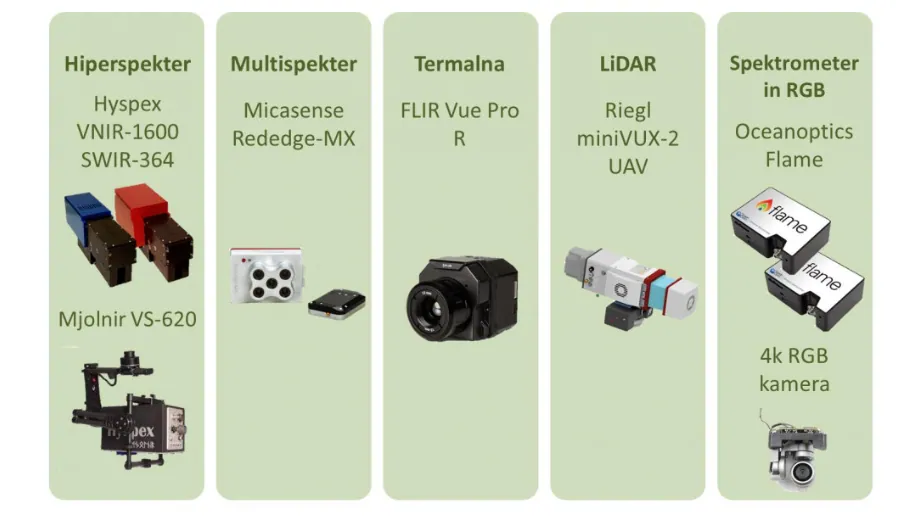
The most common groups of sensors are: RGB, hyperspectral, multispectral, thermal and fluorescence sensors. Although the detection of diseases and pests is possible with sensors of all five groups, the choice of sensor depends on the platform (greenhouse, drones, satellite...) and the desired accuracy. RGB sensors allow determining the presence of disease agents that cause changes in leaves, but their usefulness for determining infections before the development of visible symptoms is limited. The latter is made possible by multi and hyperspectral and thermal sensors. These four groups of sensors can also be used at greater distances (for example on an airplane), with natural lighting. Fluorescence sensors enable accurate disease detection and are therefore suitable for use in limited areas, such as greenhouses and laboratories.
Remote sensing sensor mounts used in agriculture
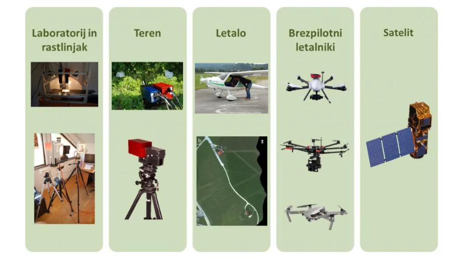
The most common carriers of remote sensing sensors used in agriculture are satellites, unmanned aerial vehicles ("drones"), aircraft, terrain, laboratories and greenhouses. Due to the heterogeneous spatial distribution of pests and diseases, remote sensing with optical sensors is the most suitable technology for providing information on foci and the extent of infections. Advanced data analysis methods are essential to effectively use remote sensing data to detect plant pests and diseases.
Precision agriculture and digitization in agriculture
For the best utilization of precision agriculture practices, we need suitable machinery and equipment, which is technically supported to enable us to carry it out. Smart machines (mineral fertilizer spreader, seeder, sprayer, grain combine, silo combine...) differ from classic machines by additional functionalities such as "Section Control", which automatically switches the "sections" on and off and thus prevents overlaps at the transitions in the fields and for side-by-side turns, it provides even crop spacing and consistent growing conditions, especially at the field edge, and "Variable rate Control" which allows us to fertilize and spray exactly where and exactly as needed . All machines need a connection to a computer that can control them, but they are usually connected via the ISOBUS controller, which is usually located on the tractor and the data needed to control the fertilizer and spray maps are imported to it. The machinery is controlled via the ISOBUS controller. For successful operation, we also need information about the exact location, which can be obtained from various location systems, one of the most well-known is the GPS system, with which we get an accuracy of 3 to 4 meters, which is enough to apply artificial fertilizers. Greater accuracy is required for spraying and sowing, which can be obtained through RTK and provides us with an accuracy of up to 1 cm. To determine how much of something to dose in a certain area, we first need data on the requirements and the condition of the field. The necessary data can be obtained with a drone or satellite, where with the help of multispectral sensors we can detect the condition of the plants, and produce special vegetation indices, which show us the depressed and healthy conditions of the plot. Since we cannot determine the exact cause based on the image itself, it is necessary to go to the field and determine the causes and adjust further measures based on the findings.
Soil and environmental data and information can be accessed through a dedicated GIS web browser. The content of data and information changes dynamically. At this time, interpreted and upgraded public data of the Pedological Map of Slovenia 1:25,000, some pedological maps of a more precise scale, pedological profiles and some data from research projects on the subject of KIS soils are available. In addition, access to various information in raster format is enabled, which is important for guiding sustainable agricultural production, for protecting the environment and natural resources.
Prediction of crop irrigation using remote sensing
Proper growth and development of plants depends on an adequate amount of water. The low level of agricultural production is, among other things, a consequence of the low productivity of water use. When we decide to irrigate, it is important not to irrigate too much or too little and that the irrigation is carried out in the correct period of time.
The consequences of unprofessional irrigation have a negative impact on:
- the health status of plants, which increases the extent of plant diseases and requires greater consumption of plant protection funds,
- amount of crop,
- the quality and durability of the crop,
- the market value of the crop and thus the competitiveness of production,
- reduced uptake of nutrients into the plant and increased possibility of leaching nutrients from the root zone,
- the effectiveness and degradation of plant protection agents and increases the chances of their being washed out of the soil,
- the efficiency of water use and the economic and environmental sustainability of agricultural production, as it causes excessive consumption of water for irrigation.
Remote sensing of pests
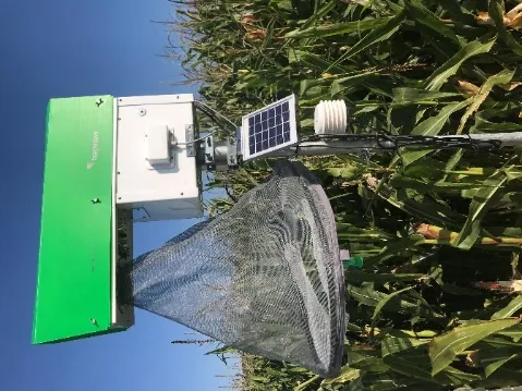
In recent years, the approach of so-called "remote detection of harmful organisms" - electronic traps - has also started to be used in the field of monitoring harmful organisms. With the help of Trapview electronic traps, it is possible to remotely monitor the appearance of pests from the Lepidoptera order, of course those for which there is a pheromone. The device consists of a solar panel, an outer casing and an interior containing electronics for image capture and data transmission and a sticky panel with a pheromone added by the user himself. The device transmits data (an image of a sticky board with catches) via the GPRS protocol to the manufacturer's server, which enables the user to view the catches via a web or mobile application. The introduction of these new technologies in the prognostic service enables the rationalization of procedures, since the current use of pheromone lures requires field visual inspections and thus material costs increase. The device is equipped with a high-resolution video camera, the data is transmitted via the mobile network, so it is possible to monitor catches in the application on a mobile phone or computer. Images of captured butterflies can be monitored via the Trapview application, which also allows the user to view recent and historical images throughout the season.